• Start
  • Previous
  • 20 /
  • Next
  • End
  •  
  • Download HTML
  • Download Word
  • Download PDF
  • visits: 6671 / Download: 2650
Size Size Size
The Unpublished Works of Arabic Geography: An Overview and a Classification

The Unpublished Works of Arabic Geography: An Overview and a Classification

Author:
Publisher: www.muslimheritage.com
English

This book is corrected and edited by Al-Hassanain (p) Institue for Islamic Heritage and Thought

Alhassanain (p) Network for Islamic Heritage and Thought

The Unpublished Works of Arabic Geography: An Overview and a Classification

by: Ayman Fuad Sayyid

Islamic geographical texts are not only valuable in terms of geographical research, they also constitute an essential resource in the study of Arab-Islamic civilisation - its literature, history, learning and economics. This chapter will attempt a classification of the major achievements of Arabic geography, introducing the reader to the principal protagonists in each field and summarising their works, many of which would benefit from further study based on the original manuscripts.

www.muslimheritage.com

www.alhassanain.org/english

[In The Name of Allah, The Beneficent, The Merciul]

Table of Contents

Note of the Editor 5

1. Introduction 7

2. Books of mathematical geography 9

3. The geographical dictionary 19

4. Geography books about the Maghrib and Andalusia 21

5. Urban descriptions and local topography 26

6. Books of travel accounts 31

7. The geographical encyclopedia 33

8. Books of administrative regional geography 38

9. Books of the wonderous and the strange 41

10. The literature of sea pilots (rahnamajat) 43

11. Summary 45

12. References 48

Note of the Editor

This article is taken from“The Earth and its Sciences in Islamic Manuscripts” (Proceedings of the Fifth Conference of Al-Furqān Islamic Heritage Foundation, pp. 175-219, 2011, ISBN 978-1-905122-12-7). We are grateful to Al-Furqān Islamic Heritage Foundation for granting permission.

Please note that the images are added to this article by the Muslim Heritage Editorial Board.

1. Introduction

Islamic geographical texts are not only valuable in terms of geographical research, they also constitute an essential resource in the study of Arab-Islamic civilisation - its literature, history, learning and economics. This chapter will attempt a classification of the major achievements of Arabic geography, introducing the reader to the principal protagonists in each field and summarising their works, many of which would benefit from further study based on the original manuscripts.

Arabic geography can be said to have its infancy with the works on geography and astronomy that appeared in the second half of the second/eighth century when Muslim scholars translated Greek works on these subjects into Arabic. Descriptive geography, a form of writing which was closely linked to travel literature, developed in the Muslim world around the third/ninth century. From this time onwards and through the fourth century hijri there was a creative flowering of Arabic geography though this development alone does not expain why such an abundance of authors left their mark in the annals of Arabic literature. These writers composed works of such a consistency of form and fluency that Kratchovsky has classified them as the ‘classical school of Arabic geography’ though they were also known as the school of al-masalik wa al-mamalik (routes and kingdoms). This development in descriptive geography was accompanied by the development of illustrative geography or mapmaking.[1]

The period from the sixth/twelfth to the tenth/sixteenth centuries also witnessed a proliferation of Arabic geographical literature. However, apart from a few exceptional works such as the writings of Sharif al-Idrisi, Yaqut al-Hamawi and Abu al-Fida, the level of geographical achievement in this period was considerably lower than that of the classical period. Possessed with sounder knowledge and a higher level of criticism than their predessors, they did not, however, produce any remarkable revelations. Essentially, these new writers’ achievement was in abridging the abundance of detailed knowledge found in the earlier literature. The period though is distinguished by the large numbers of geographers who emerged and, through their studies of the works of fellow historians and geographers they were able to broaden the scope of regional geography.

Furthermore, during this period, the centre of geographical activity changed: Egypt and Syria replaced Iraq as the centre of activities for geographic literature. There was also a great flourishing in the production of lexicons and in the development of mapmaking skills.

A European copy of al-Idrisi's map of the world, originally created at the commission of Roger II the ruler of Sicily, in the mid-12th century. © Bibliothèque Nationale de France, Paris

2. Books of mathematical geography

Mathematical geography essentially consists of representing the inhabited world by means of a grid based on lines of latitude and longitude that have been defined by astronomical measurements. This science reached the Arab world following the translation from Greek to Arabic of works by Ptolemy and others, in particular, the Zij (astonomical almanac) of Thaeon of Alexandria, the book al-Mijisti, which was translated between 175 and 180 hijri, and the work al-Jughrafiya, which was translated once by Ibn Khurdadhdhbih and either twice or three times by both Yaqub ibn Ishaq al-Kindi and Thabit ibn Qurrah al-Harrani.[2]

During the rule of the ‘Abassid Caliph al-Mamun (d. 218/833) an astronomical observatory was founded in the Shamashiyah quarter of Baghdad. Al-Mamun ordered the astronomers working in the observatory to devote themselves to testing the claims made in Ptolemy’s Zij and in al-Mijisti about the movements of the sun and other celestial bodies. As a result, numerous astronomical tables, or zij, were published which acquired the suffix, mumtahin, or ‘approved’. The scientists associated with this movement were known as the ‘masters of approval’.[3] All of these zij have since been lost except for the material which was appropriated from them by later authors for use in their own work; writers such as al-Masudi[4] and Abu ‘Abdallah Muhammad ibn Abi Bakr al-Zuhari (sixth century hijri).[5]

There is, however, an example of such zij to be found in the Escorial Library in Spain, the only remaining fruit of the astronomers of this period to have survived until the present day. This can be found under reference 924 by a writer of Persian origin, Yahya ibn Abi Mansur (d. c. 215/830). In 1986, Fuat Sezgin produced a facsimile edition of this work under the title al-Zij al-Ma’muni al-Mumtahin.

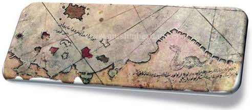
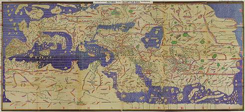
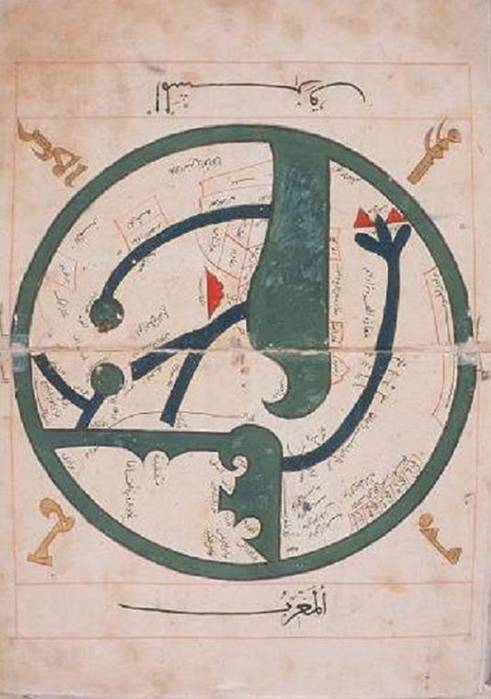
One important outcome of this enterprise was the image of the world that al-Mamun ordered 70 astronomers to create for him, an image which constitutes one of the greatest Muslim achievements in the history of science. The one surviving copy of the book, Masalik al-Absar fi Mamalik al-Amsar by Ibn Fadlallah al-Umari, kept in the Ahmet III Library in Istanbul (cat. no. 1/2797), contains an illustration of the al-Ma’mun map of the world dated 740/1340 (pp. 293-294).

Detail of the Map of the World made by the geographers of the Abbasid Caliph Al-Mamun (813-833)

One of the most important sources of mathematical geography, which had a profound influence on subsequent developments in the science, is Surat al-Ard by al-Khwarizmi.[6] Furthermore, no work on astronomy or mathematical geography that combines a scientific approach with a detailed commentary has had as triumphant an impact as al-Zij al-Sabi, which was published between 1899 and 1907 by Carlo Alfonso Nallino.[7]

The zij completed by Abu al-Hasan ‘Ali ibn Yunus al-Sadafi in Cairo was based on work began in 380/990 in the observatory on the Muqattam hills that was to become the Dar al-Hikmah (House of Wisdom) founded in 395/1005 by the Fatimid Caliph al-Hakim. This work was always associated with Hakim’s name and became known as al-Zij al-Hakimi al-Kabir. Today, there only remains a number of incomplete manuscripts of the work. Indeed, only a few short fragments of it have been published, though part of it was also translated into French by Caussin de Percival in 1803-1804.

Arabic geographical works written around the third and fourth centuries hijri can be divided into two broad categories. The first comprises work by scholars who wrote about the geography of the world and included detailed descriptions of the Islamic realm, dar al-Islam. There were also works on astronomical, physical, human and economic geography by writers such as Ibn Khurdadhdhbih, al-Yaqubi, Ibn al-Faqih and Qudamah ibn Jafar al-Masudi. This group is often known as the ‘Iraqi School’ since most of the works were produced in Iraq and the majority of the geographers were Iraqi.

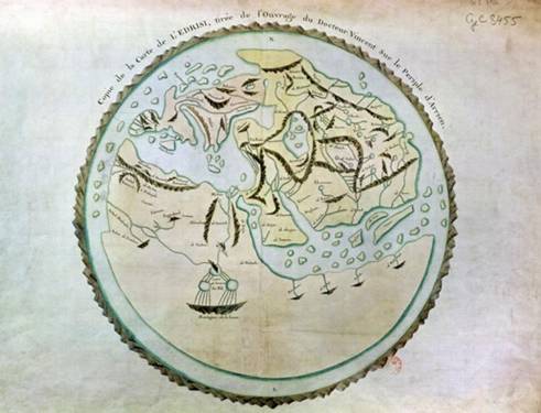
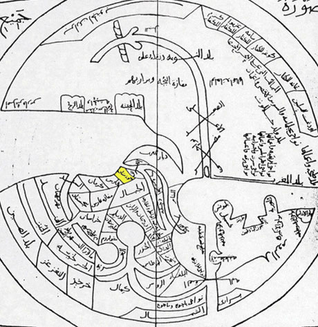
A map by Abu Zaid Ahmed ibn Sahl al-Balkhi (850-934), a Persian geographer who was a disciple of al-Kindi and also the founder the“Balkhī school” of terrestrial mapping in Baghdad. Picture displayed on“Old Manuscripts and Maps from Khorasan” .

The second category comprises work by such writers as Abu Zayd al-Balkhi, al-Istakhri, Ibn Hawqal and al-Muqaddasi al-Bashshari that dealt with the Islamic territory alone, describing every region individually. No countries outside the Islamic world appear in these works unless they happen to be adjacent to Islamic areas.[8] The literature of this ‘classical school of Islamic geography’ provides us with the most favourable description of the Islamic world since it relies on material that was either a first-hand account of the author’s travels throughout many different areas and regions, or was based on what could be gathered from people who hailed from the places described. Commentaries were added to these accounts to provide further information - on populations, systems of transport and life in general - to provide an overall picture of political, social and economic life. The works of this school are linked to a series of maps to which Kratchkovsky has given the name ‘the Islamic Atlas’, maps which represent a high point of achievement in the art of mapmaking or cartography by Arabs and Muslims.[9]

This ‘Atlas’ always contains 21 maps, produced in the same order, beginning with the circular map of the world otherwise known as the ‘al-Ma’mun map’. The main intention of the atlas is to depict the ‘Islamic world’, in accordance with the work of al-Istakhri and Ibn Hawqal in their specific way.[10]

Abu Zayd al-Balkhi (d. 322/934) was the pioneer of this school. His book, Suar al-Aqalim, was written in 308/920 or shortly thereafter. Unfortunately, there is no surviving copy of al-Balkhi’s book available to us today, nor of any manuscripts belonging to the period dominated by al-Istakhri. De Goeje’s (1836-1909) belief that al-Istakhri’s book - which was finished between 318/930 and 321/933, and therefore during al-Balkhi’s lifetime - resembles an extended copy of al-Balkhi’s book does, moreover, seem reasonable.[11]

The classical school placed a great deal of importance on producing an accurate representation of the Islamic realm, the dar al-Islam, but writings were more approximate about areas far from the centre, such as Iran and the Maghrib. The work of Ibn Hawqal was an exception, however, since he was the first to provide geographic accounts of the countries of the western Islamic world, the Maghrib, as can be seen from his book, Surat al-Ard. Editions of the latter have been prepared by both de Goeje and Kramers and a comparison of the two is valuable. There is a detailed description of the Beja region and its history, and of Eritrea which includes the names of over 200 Berber tribes, as well as a detailed description of Sicily.[12] Ibn Hawqal’s book, moreover, provides us with one of the most detailed accounts of Andalusia during the Umayyad period. This has led a good number of researchers to speculate that Ibn Hawqal was a spy for the Fatimids. In addition, Ibn Hawqal’s description of Isfahan represents the most important contribution to this literature on the eastern part of the Islamic world.

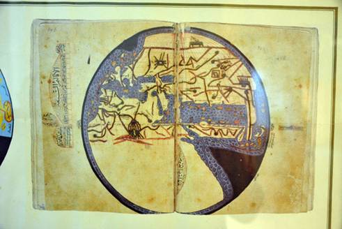
10th century map of the World by Ibn Hawqal.

The Dutch orientalist Michael de Goeje (1836-1909) was in charge of directing the Bibliotheca Geographorum Arabicorum project, which between 1870 and 1894 published volumes of works by the most important writers of the classical school: al-Istakhri, al-Muqaddasi al-Bashshari, Ibn al-Faqih al-Hamdani, Ibn Khurdadhdhbih, Qudamah ibn Ja’far, Ibn Rustah, al-Ya’qubi and al-Mas’udi. In 1906, he also published Ahsan al-Taqasim by al-Muqaddasi al-Bashshari based on a new manuscript.

To edit the texts he published in the Bibliotheca Geographorum Arabicorum, de Goeje relied on the manuscripts available at the time, however limited they were in number. The years immediately following de Goeje’s death, however, witnessed the discovery of a large number of manuscripts produced by the classical school including 12 works discovered in the libraries of Istanbul alone, some of which are very old indeed. The discovery of all these makes a compelling argument for the publication of a new edition of the first parts of the Bibliotheca Geographorum Arabicorum, which would take into account the sources used and would also compare the extracts copied into later works with the original sources now available in the newly discovered manuscripts. To this end, in 1938, J.H. Kramers produced a second edition of Ibn Hawqal’s al-Masalik wa al-Mamalik with the title Surat al-’Ard, which was based on a manuscript from the Topkapi Palace Library, in Istanbul (ref. 3346). This is an early manuscript dated 479/1086. Another edition of al-Istakhri’s al-Masalik wa al-Mamalik was published by Muhammad Jabir al-Hini in 1961.

The Bibliotheca Geographorum Arabicorum (BGA) is a series of critical editions of classic geographical texts written by several of the most famous Arab geographers.

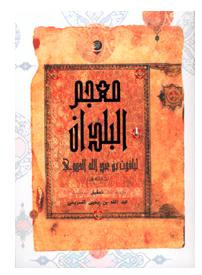
Among the books published by de Goeje was Mukhtasar Kitab al-Buldan by Ibn al-Faqih al-Hamadani. The text studied was an abridgement made in 413/1022 by Abu al-Hasan ‘Ali ibn Ja’far al-Shirazi, who may have been the same copyist who transcribed the copy of Islah al-Mantiq by Ibn al-Sikkit, which is kept in the Kubrili Library, and the Diwan al-Buhturi, which can also be found there. Ibn al-Nadim mentions Ibn al-Faqih’s book, Kitab al-Buldan, which he describes as comprising about one thousand pages, and adds that he extracted the book from al-Nas and passed it on to al-Jihani.[13] When a copy of the work came into the hands of al-Muqaddasi al-Bashshari it was said to consist of five volumes.[14] Ibn al-Faqih probably wrote the book in about 290/903 but subsequently it seems to have disappeared for some time. During the beginning of the seventh century hijri, Yaqut al-Hamawi came across the original rough draft of the book from which he transcribed extensive extracts. In 1924, the Turkish scholar Zaki Walidi Tughan found the second part of the original draft, covering Iraq and the regions of Central Asia, in a geographic collection (ref. 5229) in the scientific library of Mashhad, Iran. When this collection was published in facsimile form by Fuat Sezgin in 1987, it also included an incomplete copy of the travels of Ibn Fadlan and two texts by Abu Dulaf Mas’ar ibn Muhalhil al-Khazraji al-Yunbui describing his journey to China and the travels he made in Azerbaijan and Persia in 331/941. It follows, therefore, that the version of Ibn Khurdadhdhbih’s al-Masalik wa al-Mamalik, which was published by de Goeje, contains only the first draft of the original book.

In addition to these literary works from the classical school that have survived and been published in the present day, there are also geography books from this period whose originals have been lost and which remain in a fragmentary form only where extracts from them have been copied by later writers. Ibn al-Nadim recalls that,“the first person to publish a book in the al-Masalik wa al-Mamalik and which he did not finish was Abu ‘Abbas Ja’far ibn Ahmad al-Marwazi” .[15] Ibn al-Nadim adds that his writing was very good but that the author passed away in al-Ahwaz and he took the book to Baghdad and sold it to someone in the physician al-Harrani’s circle in the year 284/897.[16] This date coincides with the time that Ibn Khurdadhdhbih’s finished the first, and perhaps even the second, draft of his book of the same title.

Ibn Khurradadhbih’s Kitab al-Masalik wa l-Mamalik and part of the Kitab al-Kharajby Qudama ibn Jaʿfar

Al-Marwazi’s book disappeared after it was sold into the al-Harrani circle. History does not furnish us with any further information on his work other than meagre signs and excerpts, preserved for us by Ibn al-Faqih al-Hamadani and Yaqut al-Hamawi, that comment on Turkish tribes and a downpour of stones.[17] From these bits and pieces Kratchkovsky has concluded that al-Marwazi made a valuable contribution and left his mark on the geography of Central Asia!

A prominent practitioner of this period who left a deep impression on the growth and development of Arab geography was the writer Abu ‘Abdallah Ahmad ibn Muhammad ibn Nasr al-Jihani. Al-Jihani was the wazir to Nasr ibn Ahmad al-Thani al-Samani, the ruler of Khorasan and, according to Ibn al-Nadim, published a title in the series al-Masalik wa al-Mamalik, probably before 310/922.[18] Al-Muqaddasi mentioned that he saw this work, in seven bound volumes, in the ruler’s archives[19] but unfortunately it is no longer to be found. Since al-Jihani was a government official employed in Bukhara when he wrote his work he was able to extend his area of research into Central Asia and the Far East. Al-Jihani’s book has been used by a large number of Arab geographers and, according to al-Mas’udi, it was:“a description of the world and news of what it contains in terms of wonders and cities and civilisations and seas and rivers and the states and their populations and, apart from this, strange news and fabulous stories” .[20] The information that al-Jihani provided on the regions, cities and towns of Central Asia was al-Idrisi’s prime source for his description of the area in his book, Nuzhat al-Mushtaq.[21]

While all the al-Masalik wa al-Mamalik books mentioned above were written in Iraq and Iran, another geographer living in Egypt during the early part of the Fatimid era, al-Hasan ibn Ahmad (Muhammad) al-Muhallabi, wrote a book of al-Masalik wa al-Mamalik for the Fatimid Caliph al-’Aziz bi-Allah, which was later known simply as ‘al-’Azizi’. Al-Muhallabi’s book provided the most important source upon which Yaqut al-Hamawi drew when writing about Sudan; he quoted from it on more than 60 subjects. Al-Muhallabi did not, however, confine himself to the subject of Africa alone and Yaqut was to return time and again to his work to check on a wide variety of matters.[22] Yaqut also visited al-Muhallabi informally and recorded the personal details of their meetings for prosterity.[23]

The loss of al-Muhallabi’s work is particularly sad. Yaqut did not preserve it for us, though he mentions it 60 times, nor did Abu al-Fida’, who mentions it on 135 occasions, though he did use a number of excerpts from it ranging from the extremely short to the very long. It is evident that these two writers considered al-Muhallabi to be among the greatest of geographers. While Abu al-Fida’ referred to al-Muhallabi only in terms of his commentaries on the countries of the Islamic world, from the excerpts which appear in Yaqut al-Hamawi’s work we can ascertain that in his book al-Muhallabi crossed the borders of the Islamic world and ventured into neighbouring lands.[24]

In the summer of 1957, Salah al-Din al-Munajjid found a part of this lost book in the Ambrosiana Library in Milan, where it was discovered within a collection of Yemeni material. It had been transcribed by Muhammad ibn al-Hasan al-Kala’i (d. 404/1013 or later) and begins:“Muhammad ibn al-Hasan al-Kala’i: Taken from a book of the ‘Azizi al-Masalik wa al-Mamalik, a work by the writer al-Hasan ibn Muhammad al-Muhallabi” . Al-Kala’i had transcribed sections on Jerusalem, the state of Egypt and a description of Damascus.[25] Al-Muhallabi’s book is important for its direct knowledge of the rule of the Tamurlanes and was used as such at the beginning of the ninth century hijri, but it was also relevant given it provided material of a geographical nature.

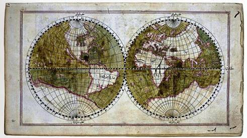
World Map, Müteferrika edition of Tuhfat al-Kibar, Topkapi Museum Library

While al-Muhallabi was one of the first geographers to provide a description of Sudan, another account is to be found in the work of the Egyptian, Abu Muhammad ‘Abdallah ibn Ahmad ibn Sulim al-Aswani; Akhbar al-Nubah wa al-Maqurah wa ‘Alwah wa al-Bujah wa al-Nil wa Min ‘Alayh wa Qurb Minh. Al-Aswani lived around the middle of the fourth/tenth century and was dispatched by (and on written order of) the Fatimid ruler, Jawhar al-Saqlabi, to the Nubian King Qibirqi. He was entrusted with the tasks of explaining Islam to King Qibirqi and of improving the settlement of the tribute that the kings of Nubia were expected to pay annually to the rulers of Egypt. Al-Aswani’s mission to Nubia appears to have taken place in the period between 358 hijri (the date of Jawhar’s arrival in Egypt) and 363 hijri (the arrival in Egypt of his successor, al-Mu’az).

Al-Maqrizi records that al-Aswani dedicated his book to the second Fatimid caliph, al-’Aziz bi Allah, who ruled between 365 and 386 hijri.[26] The book itself contains a brief account of all the places that he visited and the people who inhabited them. His description of the Nile constitutes a unique contribution to the literature of early Arab geography in that it extended Arab knowledge of the upper reaches of the river. It would appear that this work, which is also now lost, is not known outside Egypt, although al-Idrisi’s description of the course of the upper Nile is clearly indebted to a transcription of these sources; clearly then, al-Idrisi must have had it close at hand. Yet today, we only know about al-Aswani’s work from the citations transcribed from it by three Egyptian writers: al-Maqrizi, Ibn Iyyas and al-Manufi.[27]

3. The geographical dictionary

This genre of geographical literature developed from the efforts of Arab linguists - whom Yaqut al-Hamawi described as ‘the founding fathers of the literature’ - in the second century hijri.[28] In seeking to record all Arabic and Bedouin placenames they founded a literature that continued to develop over the course of time leading to the appearance of Mu’jam ma Ist’ajam by Abu ‘Ubayd al-Bakri in the fifth century hijri and Yaqut al-Hamawi’s, Mu’jam al-Buldan in the seventh century hijri. In his introduction, Yaqut al-Hamawi mentions the most important writers published in this tradition; Abu Sa’id al-Asma’i, Abu ‘Ubayd al-Sukuni, Al-Hasan ibn Ahmad al-Hamadani, Abu al-Ash’ath al-Kindi, Abu Sa’id al-Sirafi, Abu Muhammad al-Aswad al-Ghundujani, Abu Ziyad al-Kalabi, Abu Muhammad ibn Idris ibn Abi Hafsah, Abu al-Qasim al-Zamakhshari and his student, Abu al-Hasan al-’Amrani, Abu Bakr Muhammad ibn Musa al-Hazimi, Abu Musa Muhammad ibn ‘Umar al-Isfahani and Abu al-Fath Nasr ibn ‘Abd al-Rahman al-Iskandari.[29]

Yaqut's Arabic text of Mu'jam al-Buldan (Abu Dhabi, 2002)

Copies exist of works by other writers whose efforts were not republished after their first appearance: Kitab al-Amkinah wa al-Miyah wa al-Jibal by Abu al-Fath Nasr ibn ‘Abd al-Rahman al-Iskandari (d. 561/1165), a copy of which can be found in the British Library (ref. 23603), and Ma ittafaqa Lafaduhu wa iftaraqa Musammah fi al-Amakin wa al-Buldan al-Mushtabihah fi al-Khatt by Abu Bakr Muhammed ibn Musa ibn ‘Uthman al-Hazimi (d. 684/1188). These were published in facsimile form by Fuat Sezgin in 1986 and 1990 respectively.

Mu’jam al-Buldan by Yaqut al Hamawi (d. 626/1229) was completed in 621/1224 and provides a compilation of contemporary geographical knowledge, replete with information of a historical, geographical and social nature. It is a priceless resource for anyone studying Arab historical geography. A basic edition of Mu’jam al-Buldan was published in a book by Wüstenfeld between 1866 and 1873. It is considered one of the most distinguished pieces of European Orientalism on Arabic literature. Unfortunately, however, the book did not really receive the treatment that it deserved in terms of scientific rigour as the original text was not published alongside the edited version.

A new edition would be valuable, therefore, if it also included the text of Yaqut al-Hamawi’s other work, Al-Mushtariq Wad’an wa al-Muftariq Saq’an. This would constitute a true compendium of the subjects included, restoring all those that were mentioned by name only and were removed to make the text easier for revision. The geographical dictionaries published after al-Hamawi’s include some excellent examples such as al-Rawd al-Mi’tar fi Khabar al-Aqtar by ‘Abd al-Mun’im al-Himiari and Marasid al-Ittila’ by Ibn ‘Abd al-Mu’min, which is an abridgement of Mu’jam al-Buldan.

4. Geography books about the Maghrib and Andalusia

With the exception of the works of al-Idrisi, no single, complete book published in Arabic in Muslim Spain on the geography of the area has survived intact to the present day. For example, of the geographical introduction written by Ahmad ibn Muhammad al-Razi (d. 334/946) for his book Akhbar Muluk al-Andalus, all that remains are basic literal translations in Portuguese and Spanish and a few scattered excerpts in other books, in particular al-Maqqari’s work, Nafh al-Tib.[30] Nor do we have a copy of al-Jughrafiyah by Muhammad ibn Abi Bakr al-Zuhri (d. 545/1151), except for small fragments that appear to be part of an abridgement of the original work, based either on the book itself or on the al-Ma’mun map of the world, created by 70 philosophers on the orders of Caliph al-Ma’mun in Iraq.[31] Similarly, there is no extant copy of Nizam al-Marjan fi al-Masalik wa al-Mamalik by Ahmad ibn ‘Umar ibn Anas al-Udri al-Dala’i (d. 476/1083 or 478/1085 at Valencia). The exception to this is a collection of papers, disordered and unnumbered, some of which deal with Muslim Spain. These were published by ‘Abd al- ‘Aziz al-Ahwani under the title Tarsi’ al-Akhbar wa Tanwi’ al-Athar wa al-Bustan fi Ghara’ib al-Buldan wa al-Masalik ila Jami’ al-Mamalik in Madrid, in 1965.

Nothing remains of the works of Muhammad ibn Yusuf al-Warraq (d. 363/973) other than excerpts preserved in part by Abu ‘Ubayd al-Bakri and Ibn Adhari. Yusuf al-Warraq published a thick volume on the kings of Africa and their followers for the victorious ruler, which was subsequently selected by Abu ‘Ubayd al-Bakri for his book al-Masalik wa al-Mamalik. While al-Bakri attributes some quotations to al-Warraq, at other times there appears to be no fine distinction made between what is al-Warraq’s material and what is al-Bakri’s. Al-Bakri - as Hussein Mu’nis indicates - was not a mere copyist but an accomplished though disregarded geographer who improved what he was transcribing, both embellishing and editing the material.[32] Muhammad ibn Yusuf al-Warraq was the first in the western Islamic sphere to write a book with the title al-Masalik wa al-Mamalik. From the excerpts transcribed in al-Bakri’s work, it is apparent that he was the first to invent the idea of mixing geography and history. An entry on any subject would be accompanied by its historical context and a detailed description of events.[33]

According to Dozy, Abu ‘Ubayd al-Bakri, ‘Abdallah ibn ‘Abd al-’Aziz ibn Muhammad (d. 487/1094) was“undoubtedly the greatest geographer to emerge from Al Andalus” .[34] He was a wide-ranging writer whose works were among a number of founding literary compositions dealing with etymology and literature. This is why Kratchkovsky considered his book Mu’jam ma Ista’jam to be not so much a text on geography as a work on language. By this comment, he sought to imply that the widespread circulation of the book, because of its subject matter, contributed to a misconception of what the book was actually about.[35] According to Abdallah al-Ghunaim, however, it was, in its day, known simply for itself, which is why it was classified as geographical. Its position was, therefore, the pivot around which al-Bakri’s lexicon revolved.[36]

A portrait of Abu Abdullah al Bakri

Al-Bakri published his book Mu’jam ma Ista’jam during the early part of his scientific life and it was the very first lexicon to be so compiled. Two editions of the book have been published. The first was by the German Wüstenfeld in Gottingen between 1870 and 1877 and was based on manuscripts from Cambridge, London, Leiden and Milan. The second edition was printed by Mustafa al-Saqqa in Cairo, between 1945 and 1951, and was largely based on a copy from Cairo’s al-Azhar Library. The latter is an early but incomplete copy transcribed in 596 hijri in beautiful Andalusi script, described by al-Saqqa as being,“superior to all the originals which exist of this book as far as the condition and precision and clarity of this edition are concerned. Furthermore, the margins of the manuscript contained notes added to the original in the handwriting of the author” . As al-Saqqa noted, the outer edges of this copy do contain marginalia, which comprise a large number of additions and corrections. The most important of these additions are transcribed in the book al-Ta’liqat wa al-Nawadir by Abu ‘Ali al-Hajari, although he draws no benefit from them and even manages to obscure some. On examining the al-Azhar copy, ‘Abdallah al-Ghunaim discovered that these additional notes, of which there are around 80, are concerned with new subjects in addition to those included in the book, annotated in the margins alongside their entries in the order in which they appear in the lexicon.[37]

Ibn Sa’id al-Maghribi relied on Al-Mushib fi Fada’il (or Ghara’ib) al-Maghrib by ‘Abdallah ibn Ibrahim ibn Wazmar al-Hajjari (d. 550/1155) as the main source for his extensive study, al-Mughrib fi Hulay al-Maghrib, which he called Jahiz al-Maghrib.[38] It is rare to come across any Andalusian writer after al-Hajjari who does not refer to him; an indication that his book was both reliable and thorough. Unfortunately, Ibn Sa’id mixed up his own words with those of al-Hajjari. He made extensive changes and replacements and although there are over 250 extracts, we do not know if these are faithful transcripts or whether they include additions and deletions.[39] For this reason, al-Maqqari refers to it in a chapter devoted to Andalusian geography at the beginning of his Nafh al-Tib: this contains 20 long citations that form the core of that chapter. Throughout the rest of Nafh al-Tib, al-Maqqari includes extensive passages from al-Hajjari’s al-Mushib. Some of these cover the general geography of Andalusia while others deal with descriptions of the cities and particularities of the regions.[40] As far as general geography is concerned, al-Maqqari distinguishes himself but, as far as the regions are concerned, we find every thought on a particular subject is present in the same order as it appears in Ibn Sa’id’s al-Maghrib.[41]

Hussein Mu’nis claims that the passages dealing with the general descriptive geography of Andalusia were to be found in the chapter missing from Ibn Sa’id’s al-Maghrib manuscript that was published under the title Wash’y al-Tarash fi Hulay Jazirat al-Andalus.[42] That al-Maqqari (d. 1041/1641) was able to make use of al-Hajjari’s book indicates that it must have been written around this time and disappeared shortly thereafter. This is the case with many of the copies referred to here, which were once available but now lost, for example parts of Tarikh Ibn Khaldun and al-Ihatah fi Akhbar Gharnatah by Lisan al-Din ibn al-Khatib.[43]

Location of Andalusia within Spain. (Capital also shown.)

With reference to Ibn Sa’id, another valuable book which has been lost is the work of the geographer Ibn Fatmah who lived during the sixth/twelfth century. Unfortunately, we do not even know the full name of this man whose work is considered to be some of the best ever written by a Muslim about the regions that lie to the south of the Sahara.[44] Both Ibn Sa’id and Ibn Khaldun confirmed that they had drawn heavily on this work and copied extensive passages from it. These transcriptions clearly indicate that his writing contained quite detailed information about Africa and its inhabitants south of the Sahara. Ibn Fatimah himself hailed from western Sudan and made extensive journeys along the African coast, travelling as far as Somalia and Ethiopia. He then penetrated deep into the continent and saw the source of the Nile. His account and observations provide a very clear guide to the region.[45]

The most important of the geographers in the western part of the Muslim world was undoubtedly the great al-Idrisi, Abu ‘Abdallah Muhammad ibn Muhammad ibn ‘Abdallah ibn Idris, who died in his birthplace, Ceuta, in 560/1160. His book, Nuzhat al-Mushtaq fi Ikhtiraq al-Afaq, is the most well-known work on Arab geography in Europe, in general, and among orientalists in particular. Indeed, there is no finer book on Arab geography. Its fame is derived from the fact that al-Idrisi was an Arab geographer who spent most of his life in Sicily. Sicily was, by a wide margin, the place in Europe most strongly influenced by the Islamic civilisation. It follows, therefore, that an abundance of documentation was to be found in Sicily in its day. Al-Idrisi published his book there in response to a request by Roger II, King of Sicily. For a long time, al-Idrisi was the sole representative of Arab geographical literature in European scientific circles and he came to be considered the greatest of all geographers, without exception, within the general framework of Arab geography.[46]

While al-Idrisi’s Nuzhat al-Mushtaq has been published numerous times, the most important edition is the one printed by the Institute of Eastern Studies at the University in Naples (1970-1984). Al-Idrisi’s last book, Uns al-Muhaj wa Rawd al-Furaj, was published by Roger II’s son, Guillaume I, King of Sicily (1154-1166).[47] A copy of this work was discovered in the Hakim Uglay Ali Pasha Library in Istanbul by the orientalist Joseph Horowitz (ref. 688), but it has still not been published. In the introduction, the author describes his satisfaction with“the abbreviations and omissions of the prattle and excesses” referring to its being based on the same sources that are used in Nuzhat al-Mushtaq. Horowitz also found a reference to another copy stored in the Hasan Hasanu Library in Istanbul (ref. 1289) The copy in the Hakim Uglay Ali Library includes an atlas of 73 maps, which were published by Müller, in 1926, under the title Pocket Atlas. To date, no one has studied the link between al-Idrisi’s manuscript and the edition published by Fuat Sezgin in facsimile form, in 1984.

The Tabula Rogeriana, drawn by al-Idrisi for Roger II of Sicily in 1154, one of the most advanced ancient world maps. Modern consolidation, created from the 70 double-page spreads of the original atlas.

5. Urban descriptions and local topography

One of the most important sources provided by the introductions of books dealing with the history of the larger Islamic cities is their descriptions of the cities’ topography. The majority of topographical descriptions, such as those which appear in the foreword to Tarikh Baghdad by al-Khatib al-Baghdadi or the foreword to Tarikh Madinat Dimashq by Hafiz ibn Asakir, were matters of specialist study. Whether by intention or not, those histories that are accompanied by a description of the city’s topography throw light on the subject for the reader as though it were being explained by a teacher of antiquity.

Egyptian authors alone were particularly distinguished by their specialism in topography, a skill that had developed during the Fatimid period and reached its zenith in the ninth/fifteenth century with the work of the well-known historian and topographer, Taqi al-Din Ahmad ibn ‘Ali al-Maqrizi.[48] The first book published to provide a plan of Egypt was by Hasan ibn Muhammad ibn Zulaq (d. 386/996) during the early part of the Fatimid period; no copy of this has survived to the present day. This was followed by ‘Abdallah Muhammad ibn Salamah ibn Ja’far al-Quda’i’s (d. 454/1062) al-Mukhtar fi Dhikr al-Khitat wa al-Athar. Al-Quda’i wrote this prior to the years of the so-called al-shiddah al-mustansiriyah, or anti-Christian violence, of the middle of the fifth century hijri, which greatly changed the situation for scholars in Fustat Egypt. Thus al-Maqrizi writes: ‘More were wiped out than they say and it will not be cleared up until light is thrown on the matter or what happened in Egypt in the year of the violence is solved’.[49] Al-Quda’i’s book did not disappear, like so many other sources from the Fatimid period, until much later and extensive passages were transcribed both from al-Qalqashandi and al-Maqrizi in the ninth/fifteenth century. He was considered current up to the first decade of the tenth century hijri when al-Suyuti (d. 911/1505) used an account of the conquest of Egypt in his Husn al-Muhadarah referring to a copy of al-Quda’i’s book, which was transcribed in al-Quda’i’s own handwriting.[50]

Egyptian books of graphic description that have not managed to survive to the present day include Khitat Misr by Muhammad ibn Barakat ibn Hilal al-Nahwi al-Misri who died in 520/1126 at the age of almost one hundred. Al-Maqrizi came across a copy of book transcribed by al-Sharif Muhammad ibn As’ad al-Jawwani (d. 588/1092).[51] Al-Jawwani himself published his own book on the subject under the title Al-Nuqat bi ‘Ujm ma Ushkil min al-Khitat. There are no extant copies of this work although al-Maqrizi did transcribe a number of extracts from a copy handwritten by the author himself.[52]

The first person to complete a book giving a graphic description of Cairo was Qadi Muhyi al-Din Abu al-Fadl ‘Abdallah ‘Abd al-Zahir (d. 694/1293). The title was al-Rawdah al-Bahiyah al-Zahirah fi Khitat al-Mu’iziyah al-Qahirah. Until recently, Ibn ‘Abd al-Zahir’s book was thought to have been lost but it was announced that a copy had been found in the British Library by Abdallah Yusuf al-Ghunaim.[53] This copy was published in Cairo, in 1996.

Qadi Taj al-Din Muhammad ibn ‘Abd al-Wahab ibn al-Mutawwaj (d.730/1330) wrote a graphic description of Fustat in Egypt under the title Iqadh al-Mutaghaffil wa Itti’adh al-Muta’ammil. Al-Maqrizi described this as a large book compiled in 725 hijri.[54]

A drawing of Fustat, from Rappoport's History of Egypt

Sarim al-Din Ibrahim ibn Muhammad ibn Aidumur al-‘Ala’i, known as Ibn Duqmaq (d. 809/1407), wrote a book entitled al-Intisar Liwasitat ‘Aqd al-Amsar. Of this, only the fourth and fifth parts have survived in the form of part of a rough draft written by the author himself. These two surviving parts comprise descriptions of Fustat and Cairo. G. Salmon considers him for this reason to be the best guide possible to the topographical construction of Fustat, the camps and the part of Islamic Egypt which later became Cairo.[55] This draft is now stored at the Egyptian National Library (ref. 1244, History). It was published by Vollers, in 1893, in a rather poor edition - a good argument for republishing it in the same way that many of the books that were printed in the nineteenth century should be reissued, in accordance with the current scientific standards adopted when publishing heritage works.

These authors led the way for later achievements in this branch of Arab geographical literature, as exemplified by the writings of the master historian of Islamic Egypt, Taqi al-Din Ahmad bin ‘Ali al-Maqrizi (d. 845/1442), in his Al-Mawa’iz wa al-I’tibar fi Dhikr al-Khitat wa al-Athar. Al-Maqrizi certainly made a great impression with his scientific endeavours, covering both history and historical geography on a wide front. There are a number of studies devoted to him and, in 1995, al-Furqan Islamic Heritage Foundation published a draft of the book that had been handwritten by al-Maqrizi himself.

One of the most important sources of Egyptian graphical description is a book attributed to Abu Salah al-Armani, a part of which was published in Oxford, in 1895, by the orientalist Evetts, based on a copy stored in the Bibliotheque Nationale, in Paris (ref. 357). The book comprises a topographic description of churches and important places in Egypt; its material is divided into subjects according to geographic distribution. In 1984, the monk Samuwil al-Suryani published a new edition of the work, including the part published by Evetts in the second half of his volume. The first part contains material published for the first time on churches and gives information on the coastal regions as well as a section on Cairo. The second part comprises descriptions of churches, a part of Cairo and the southern regions of Egypt.

The“Hanging Church” in Cairo

Samuwil al-Siryani copied the text out by hand, and supplemented it with material taken from a new manuscript though he failed to provide any catalogue description of this source. What was new about this rather humble edition was the detection of the work’s actual author who turned out to be the previously unknown al-Shaykh al-Mu’taman Abu al-Makaram Sa’d Allah ibn Jirjis ibn Mas’ud. Abu Salah al-Armani, to whom the book had previously belonged, was only responsible for the second part of the copy now stored in the Paris library. The main part of the book was written by Abu al- Makaram between 555-583/1160-1187.[56] The manuscript on which Samuwil al-Siryani worked is currently stored in Munich, at the Bayerischen Staatsbibliothek (ref. 2570). Prior to that, it was in the possession of a Copt, in Tanta, called Jirjis Falta’us ‘Awad. ‘Ali Basha Mubarak learned of the manuscript and managed to gain access to it, drawing on it greatly for the sixth part of his book al-Khitat al-Tawfiqiyah al-Jadidah.[57] Hence too, then, there is a good argument for republishing this book, applying the correct scientific procedures to ensure the manuscript’s accuracy, because of its rarity and the importance of its subject matter.

Some of the books of graphic description that emerged in Cairo after al-Maqrizi have never been published. Al-Tuhfah al-Fakhirah fi Dhikr Rusum Khitat al-Qahirah written by someone called Uqbugha al-Khasiki, and which was written for the honourable Sultan Qansuh al-Ghuri, is an example of these. The Bibliotheque Nationale de Paris keeps a copy of this (ref. 2265), which appears to be no more than the second part of al-Maqrizi’s book, begins with an account of Herat, and contains only some slight changes to al-Maqrizi’s approach.

Qatf al-Azhar min al-Khitat wa al-Athar, by Muhammad ibn Muhammad ibn Abi al-Surur al-Bakri al-Siddiqi (d. 1060/1650), is an abridgement of al-Maqrizi’s work, but with additions in terms of subject matter and information from the Ottoman period. A copy of this is to be found in the Egyptian National Library (ref. 457 Geography and ref. 53 Tamurlane).